Interactive maps help secure land rights for indigenous peoples

A global interactive map called LandMark helps indigenous peoples worldwide prove that their land is not vacant, idle, or available for outside exploitation.

|
Lunae Parracho/Reuters/File
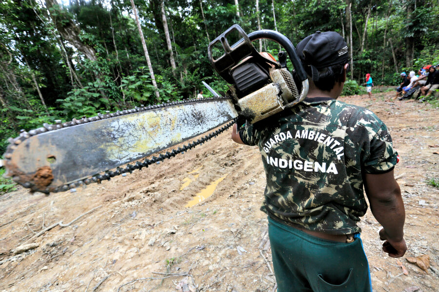
A Ka'apor Indian warrior carries a chainsaw confiscated during a jungle expedition to search for and expel loggers from the Alto Turiacu Indian territory in the northeast of Maranhao state in the Amazon basin of Brazil.

Indigenous peoples whose land rights have often been exploited due to lack of maps and data have a new tool to help secure their rights: a global interactive map of the land they claim called LandMark.

Indigenous peoples and communities claim to hold about two thirds of the world's land but are legally recognized as holding only 10 percent, according to think thank World Resources Institute (WRI), one of the organizations behind the project.

"By visualizing the locations of indigenous peoples and local communities – involving perhaps 2 billion people – LandMark pushes their existence into the calculations of those making decisions about climate change, economic development, poverty alleviation, and natural resources conservation," Peter Veit, director of the WRI's Land and Resources Rights initiative, said in a statement.

"LandMark provides indigenous peoples and communities the opportunity to be proactive in their efforts to protect their lands, not just reactive to imminent threats."

Without legal rights to land, indigenous communities may find their land is taken over for the exploitative development of natural resources, palm oil plantations, and logging, according to the WRI.

Mapping their territory gives them an opportunity to show that their land is not vacant, idle, or available for outsiders, it said.

The WRI said last week that ensuring rain forest communities have secure land rights could reduce deforestation and land-use conflicts and prevent tens of millions of tons of carbon dioxide emissions each year.

Developed by a partnership of indigenous groups and land rights and research bodies, the beta version of the map launched Nov. 10 shows the boundaries of thousands of pieces of land claimed by indigenous people and communities around the world.

It offers additional information about the lands such as land category and area.

Still in the development stage, the map is not a "crowd-sourcing" platform but aims to provide only high-quality data available from recognized organizations and experts who can submit their entries directly through www.LandMarkMap.org.

• Reporting by Magdalena Mis, editing by Tim Pearce. This story was originally published on the website of the Thomson Reuters Foundation, the charitable arm of Thomson Reuters that covers humanitarian news, women's rights, corruption, and climate change. Visit www.trust.org.

You've read  of  free articles. Subscribe to continue.
Real news can be honest, hopeful, credible, constructive.
What is the Monitor difference? Tackling the tough headlines – with humanity. Listening to sources – with respect. Seeing the story that others are missing by reporting what so often gets overlooked: the values that connect us. That’s Monitor reporting – news that changes how you see the world.

Dear Reader,

About a year ago, I happened upon this statement about the Monitor in the Harvard Business Review – under the charming heading of “do things that don’t interest you”:

“Many things that end up” being meaningful, writes social scientist Joseph Grenny, “have come from conference workshops, articles, or online videos that began as a chore and ended with an insight. My work in Kenya, for example, was heavily influenced by a Christian Science Monitor article I had forced myself to read 10 years earlier. Sometimes, we call things ‘boring’ simply because they lie outside the box we are currently in.”

If you were to come up with a punchline to a joke about the Monitor, that would probably be it. We’re seen as being global, fair, insightful, and perhaps a bit too earnest. We’re the bran muffin of journalism.

But you know what? We change lives. And I’m going to argue that we change lives precisely because we force open that too-small box that most human beings think they live in.

The Monitor is a peculiar little publication that’s hard for the world to figure out. We’re run by a church, but we’re not only for church members and we’re not about converting people. We’re known as being fair even as the world becomes as polarized as at any time since the newspaper’s founding in 1908.

We have a mission beyond circulation, we want to bridge divides. We’re about kicking down the door of thought everywhere and saying, “You are bigger and more capable than you realize. And we can prove it.”

If you’re looking for bran muffin journalism, you can subscribe to the Monitor for $15. You’ll get the Monitor Weekly magazine, the Monitor Daily email, and unlimited access to CSMonitor.com.

QR Code to Interactive maps help secure land rights for indigenous peoples
Read this article in
https://www.csmonitor.com/World/Making-a-difference/Change-Agent/2015/1116/Interactive-maps-help-secure-land-rights-for-indigenous-peoples
QR Code to Subscription page
Start your subscription today
https://www.csmonitor.com/subscribe