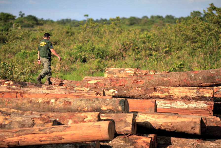
How satellite maps can halt Amazon deforestation
Loading...
In the heart of the Brazilian Amazon, a group of scientists have become unconventional crusaders in the battle to halt deforestation. They are the engine behind Imazon, one of the most prolific research groups based in the Amazon.
Imazon is now collaborating with the government of the Brazilian state of Pará to combine real-time satellite imagery and advanced mapping techniques with a system of incentives and penalties to embolden indigenous communities, local governments, and farmers to protect the rainforest.
Until recently, Pará was the epicenter of unchecked rainforest devastation. Known locally for its rural corruption and banditry, the region had been losing 6,255 square kilometers of rich biodiversity annually – an area roughly the size of Delaware. The assault threatened the territory of some of the last untouched tribes in the world, and chipped away at the Amazon’s ability to absorb 1.5 billion tons of carbon dioxide from the atmosphere each year, a critical factor in regulating the earth’s climate cycle.
But the Brazilian Amazon is vast. Patrol vehicles can’t monitor the entire region from the ground. This is particularly true for indigenous communities trying to oversee their protected lands with limited resources.
And without accurate and timely information about illegal logging and sawmills, authorities and community members are helpless to stop the destruction before it it’s too late.
That’s why Carlos Souza Jr., a native of Pará’s capital of Belem, got involved. Souza earned a doctoral degree in advanced image-processing techniques from the University of California-Santa Barbara and recognized that this technology could be the crucial missing link to address deforestation in his home country. Souza and a small team of researchers at Imazon developed detailed maps using free satellite imagery from the NASA sensor MODIS.
But the end goal was not just to produce beautiful maps.
Souza and his team began tracking changes in deforestation. They used the information to spark frank discussions about the future of the Amazon and to push for informed action on the issue. In some cases this meant cracking down on illegal operations, and in others it meant training farmers in improved farming techniques to enable higher incomes.
“Using scientific methods to approach sustainable development puts Imazon in a very good position to host dialogues with different stakeholders because the information we produce is neutral,” Souza explains. “They may not agree with the results, but they know there is no bias.”
For Souza and the Imazon team, this is the real value of their program: putting detailed scientific data in the hands of the people who can create positive change.
And it’s started to work.
In early 2013, the Brazilian police and army from the community of Nova Esperança do Piria used Imazon’s satellite images to conduct large-scale raids on unlicensed sawmills that were infringing on the Alto Guáma Indigenous Reserve, situated within the Amazon.
Last year, Imazon expanded its work with support from the Investment Innovations Alliance, a joint venture fund between USAID and the Skoll Foundation, in collaboration with Mercy Corps. The Alliance invested $6 million, which allowed Imazon to grow and institutionalize its cartographic monitoring system and support the expansion of the Green Municipalities Program.
Deforestation is already on the decline: After rising in the first half of 2013, the deforestation rate between August and December decreased by 70% compared to the same period the year before.
Now Imazon wants to take this movement beyond Brazil’s borders.
The launch of Google Earth Engine has allowed Imazon to share their pioneering maps with the global community, and they are connecting with leading organizations throughout the region that want to integrate Imazon’s approach.
Souza is optimistic about the organization’s ability to adapt their strategies and burgeon their impact as they continue in the battle to preserve the world’s most pristine rainforests.
• This story was written by Rachel Huguet, Assistant Program Officer, Investment Innovations Alliance. The original story at Global Envision, a blog published by Mercy Corps, is here.
• Headquartered in Belém, Brazil, Imazon is a nonprofit organization focused on promoting sustainable development in the Amazon rainforest. In 2013, the Innovation Investment Alliance—a partnership between USAID and the Skoll Foundation, supported by Mercy Corps—invested in Imazon to support the decentralization of deforestation control and management across 50 municipalities in the state of Pará.
• The U.S. Agency for International Development (USAID) is the lead U.S. government agency that works to end extreme global poverty and enable resilient, democratic societies to realize their potential. USAID recently launched the U.S. Global Development Lab, a new entity within USAID that seeks to increase the application of science, technology, innovation, and partnerships to achieve, sustain, and extend the Agency’s development impact to help hundreds of millions of people lift themselves out of extreme poverty.
• The Skoll Foundation drives large-scale change by investing in, connecting, and celebrating social entrepreneurs and the innovators who help them solve the world’s most pressing problems.
• Mercy Corps helps people in the world’s toughest places survive the crises they confront and turn them into opportunities to thrive. Mercy Corps seeks innovation that creates major breakthroughs against poverty and lasting change in the places we work.


