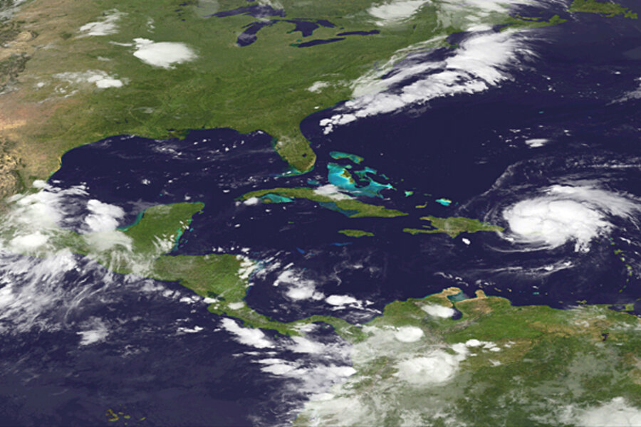
Atlantic's first 2011 hurricane, Irene, tracks toward Cape Canaveral
Loading...
Hurricane forecasters have posted hurricane and tropical-storm warnings for the island of Hispaniola and the southern Bahamas as hurricane Irene, the Atlantic season's first hurricane, crossed Puerto Rico overnight Sunday.
Irene emerges as the 2011 Atlantic hurricane season is nearly a third of the way through its peak August-to-October period. Within that span, activity peaks on average from early to mid-September.
As of 11 a.m. Eastern Daylight Time Monday, the National Hurricane Center's track forecast puts the center of Irene roughly 120 miles east of Florida's Cape Canaveral by Friday evening, with landfall currently forecast to occur just south of Charleston, S.C., at about 8 a.m. Saturday. The intensity forecast upgrades Irene to a major hurricane, with winds in excess of 110 miles per hour, by the time it reaches the central Bahamas Thursday morning. It currently is expected to make landfall as a major hurricane.
Errors are large, however, in track forecasts this far in advance. The track's "error" cone also include the possibilities that the storm could swing west and move up the Florida peninsula. Or it could track farther east than its current path indicates, pushing it closer to North Carolina's outer banks by Saturday morning.
Irene appeared as a tropical storm early Saturday evening from a cluster of thunderstorms some 175 miles east of Martinique. By early Monday morning, the center of the storm had arrived over Puerto Rico. But instead of weakening as it encountered the island, as often happens to a storm, it strengthened to a Category 1 hurricane, with maximum sustained winds of 74.8 m.p.h.
Although a formal analysis will come later, it appears that based on the storm's path, "the island was just too small" to deflate Irene, says Dennis Feltgen, a spokesman for the National Oceanic and Atmospheric Administration's National Hurricane Center in Miami.
Irene was strengthening as it approached Puerto Rico, he says, and the storm's path took the eye overland but close to the island's north coast, missing the highest, most potentially disruptive terrain.
The storm's path also left much of Irene's circulation over warm water, so Irene kept spinning up. Forecasters say they expect additional strengthening.
Irene is the ninth named storm in the 2011 Atlantic Hurricane season – a season busier so far than were 2009 and 2010.
By this time in August 2009, the season had produced three named storms, only one of which was a hurricane. But it was a strong one – hurricane Bill reached Category 4, with maximum sustained winds of more than 131 m.p.h. It spent most of its time in the open Atlantic, skirting Nova Scotia as a weak hurricane and Newfoundland as a tropical storm.
The 2010 season saw five named storms by this time in August, two of which were a Category 4 storm. Both formed in August. One, hurricane Earl, kept much of the US East Coast on edge as skirted the shore from North Carolina's outer banks to finally make landfall in Nova Scotia as a Category 1 hurricane.
One key factor behind the differences: conditions in the tropical Pacific, forecasters say.
In 2009, El Niño conditions had taken hold by July. A large pool of warm water had migrated from the western tropical Pacific to the east, off the coast of Central and northern South America. That migration altered atmospheric circulation patterns in ways that increase the amount of wind shear over the tropical Atlantic.
Wind shear shows up as changes in wind speed and direction with altitude, and when a season's average conditions include strong shear, hurricanes have a tough time forming.
El Niño's opposite, La Niña, appeared in 2010, reducing shear and establishing general atmospheric conditions that favor hurricane formation.
This year, conditions in the tropical Pacific are in a neutral phase, which also tend to make formation more likely than during an El Niño year.
In addition to their high levels of street cred as natural hazards, tropical cyclones also figure into seasonal drought forecasts as drought busters. Drought has gripped much of the southern tier of the US for months, with "extreme" to "exceptional" conditions spanning Arizona, New Mexico, Texas, Oklahoma, and much of Louisiana. Drought at lesser intensities also span much of the rest of the Southeast.
Forecasters had expected some relief for parts of southern Texas and the Southeast with the coming of the hurricane season. But air over Texas has been so dry that when tropical storm Don made landfall along Texas' Padre Island, Don dropped a paltry two-thirds of an inch of rain along the coast, far less than forecasters expected based on experience with past tropical storms or weaker tropical depressions.
By contrast, tropical depression Harvey, which made its second and final landfall along the Mexican state of Veracruz Monday morning after crossing Guatemala, was dumping between two to four inches of rain along its path, with some locations expecting to get as much as 10 inches.


