NASA maps out destruction in the Philippines to aid relief

NASA's satellites are photographing the destruction from space in hopes of directing relief workers to the most devastated areas.

|
NASA/JPL-Caltech/ASI
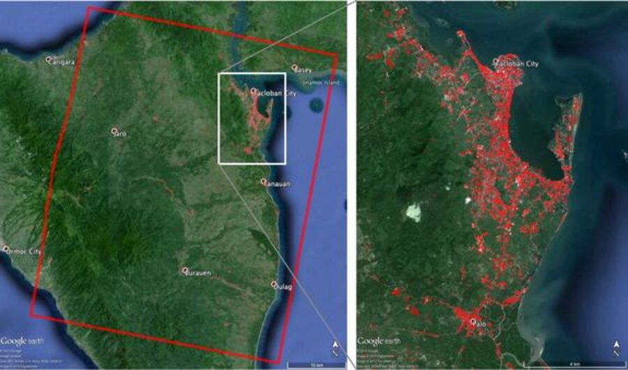
This map of the devastation from Super Typhoon Haiyan in the Philippines shows damage from the Nov. 8, 2013 storm in the hardest hit regions. NASA scientists and the Italian Space Agency used satellite views to create the maps to aid disaster relief.
|
Rich Clabaugh/Staff

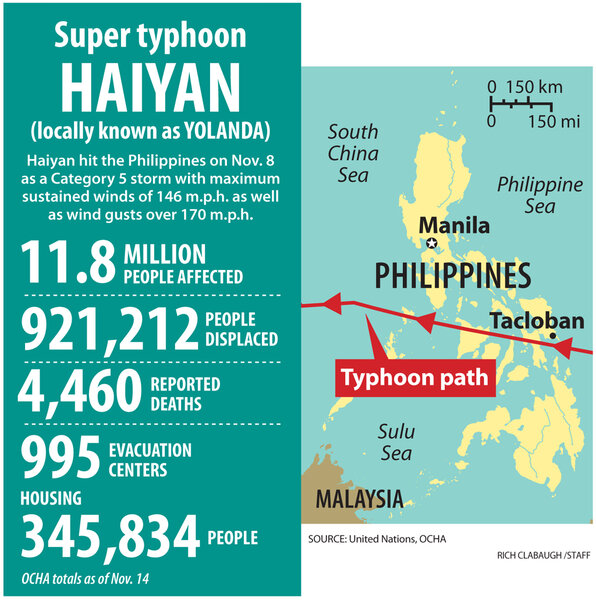
NASA scientists have used satellite images to create detailed maps of the devastation in the Philippines from Super Typhoon Haiyan in order to help disaster relief efforts by recovery crews.

Super Typhoon Haiyan — which struck the island nation on Nov. 8 — was one of the most powerful storms ever recorded, and NASA's Jet Propulsion Laboratory in Pasadena, Calif. produced the damage maps in order to depict the hardest hit regions of the country, NASA officials wrote in a news release.

JPL's ARIA (Advanced Rapid Imaging and Analysis) team created the 24.9 by 31 mile (40 by 50 kilometers) map using data from the Italian Space Agency's COSMO-SkyMed satellite constellation. The image shows the area near Tacloban City, where the storm made landfall.

NASA scientists created the damage map by using "a prototype algorithm to rapidly detect surface changes caused by natural or human-produced damage," space agency officials wrote in a release.

"The assessment technique is most sensitive to destruction of the built environment," NASA officials wrote in a statement. "When the radar images areas with little to no destruction, its image pixels are transparent. Increased opacity of the radar image pixels reflects damage, with areas in red reflecting the heaviest damage to cities and towns in the storm's path."

The scientists used data gathered from Aug. 19 to Nov. 11 to calculate the change.

Haiyan's storm surge reached up to 20 feet (6 m) in parts of the Philippines, and some estimates place the death toll at 2,000. Before it made landfall, the super typhoon had sustained winds of up to 190 mph (305 km/h). The typhoon's strength was equivalent to a strong Category 5 hurricane, tropical weather expert Brian McNoldy told LiveScience.

This is not the first time NASA has released a map of a country post-natural disaster. In 2011, the space agency put out multiple images of Japan after the country was hit by a devastating earthquake and tsunami.

Italy's COSMO-SkyMed satellite also imaged the Myanmar cyclone and Chinese earthquake in 2008, aiding in the relief effort for those two countries.

ARIA is currently a program in development. The system is designed to use images taken from space to quickly assess the impact of a disaster on a region, NASA officials said. The ARIA team plans to build "an automated system for providing rapid and reliable GPS and satellite data to support the local, national, and international hazard monitoring and response communities," NASA officials said.

You've read  of  free articles. Subscribe to continue.
Real news can be honest, hopeful, credible, constructive.
What is the Monitor difference? Tackling the tough headlines – with humanity. Listening to sources – with respect. Seeing the story that others are missing by reporting what so often gets overlooked: the values that connect us. That’s Monitor reporting – news that changes how you see the world.

Dear Reader,

About a year ago, I happened upon this statement about the Monitor in the Harvard Business Review – under the charming heading of “do things that don’t interest you”:

“Many things that end up” being meaningful, writes social scientist Joseph Grenny, “have come from conference workshops, articles, or online videos that began as a chore and ended with an insight. My work in Kenya, for example, was heavily influenced by a Christian Science Monitor article I had forced myself to read 10 years earlier. Sometimes, we call things ‘boring’ simply because they lie outside the box we are currently in.”

If you were to come up with a punchline to a joke about the Monitor, that would probably be it. We’re seen as being global, fair, insightful, and perhaps a bit too earnest. We’re the bran muffin of journalism.

But you know what? We change lives. And I’m going to argue that we change lives precisely because we force open that too-small box that most human beings think they live in.

The Monitor is a peculiar little publication that’s hard for the world to figure out. We’re run by a church, but we’re not only for church members and we’re not about converting people. We’re known as being fair even as the world becomes as polarized as at any time since the newspaper’s founding in 1908.

We have a mission beyond circulation, we want to bridge divides. We’re about kicking down the door of thought everywhere and saying, “You are bigger and more capable than you realize. And we can prove it.”

If you’re looking for bran muffin journalism, you can subscribe to the Monitor for $15. You’ll get the Monitor Weekly magazine, the Monitor Daily email, and unlimited access to CSMonitor.com.

QR Code to NASA maps out destruction in the Philippines to aid relief
Read this article in
https://www.csmonitor.com/Technology/2013/1114/NASA-maps-out-destruction-in-the-Philippines-to-aid-relief
QR Code to Subscription page
Start your subscription today
https://www.csmonitor.com/subscribe