Nor'easter forecast: It's all about location, location, location
Loading...
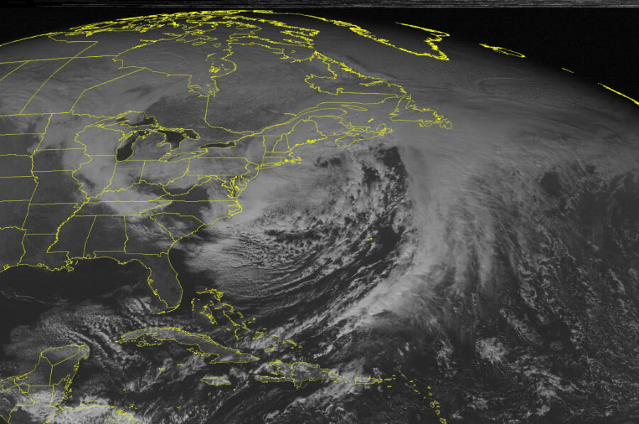
The powerful nor'easter that brought blizzard conditions to much of the coastal Northeast Monday night and Tuesday highlights the challenges tied to forecasting the details of these powerful storms.
It also hints at the challenges the National Weather Service faces as it integrates new or upgraded forecasting tools into its system – challenges that may have more to do with the pace at which individual forecasters gain confidence in the tools rather than with the tools per se.
In many respects the forecasts for the storm, particularly its effects on New England, held true. But farther south, the storm didn't follow the path forecasters expected.
This prompted Gary Szatkowski, meteorologist in charge of the National Weather Service office in Mount Holly, N.J., to take to Twitter to apologize to a heavily populated patch of the Eastern Seaboard for "a big forecast miss."
Snowfall overnight Monday along the Philadelphia-to-New York City corridor ran well below the levels forecast. The outlook had called for 24 to 36 inches. By 10 a.m. Tuesday, northeast Philadelphia had posted 2.5 inches, Newark International Airport logged six inches, and New York City's Central Park hosted 5.5 inches, according to the National Weather Service's Weather Prediction Center in College Park, Md.
Father east along Long Island, however, the overnight totals began to climb to levels that fell within the predicted range. By late afternoon Tuesday, unofficial snowfall totals in portions of Connecticut, eastern and central Massachusetts, and parts of Rhode Island fell well within the 24-to-36-inch range. Coastal communities experienced severe high-tide flooding, which was forecast. Colder-than-expected temperatures kept power outages to a minimum by making the snow light enough so that the wind could remove it from trees and power lines.
Four to five days in advance, forecasters saw the potential for a powerful coastal storm that could deliver heavy snow to the Northeast, noted Louis Uccellini, director of the National Weather Service, during a briefing Tuesday afternoon.
"But we still have forecast challenges," he said.
One may involve trust in the tools – in this case, members of the suite of five forecast models that Weather Service forecasters use to help inform their predictions.
A full evaluation of how the models performed and how the forecasters used them is pending. But one of the five, called the Global Forecast System model, had the storm taking a more easterly path than did other models, including one run by the European Centre for Medium Range Weather Forecasts. That model called superstorm Sandy's left turn into the East Coast roughly a week ahead of time, well before other models that forecasters used projected the course change.
This time around, however, the Global Forecast System model, run at the National Centers for Environmental Prediction (NCEP) in College Park, called the nor'easter's path correctly in advance, projecting the lower snowfalls that the New York City area experienced.
An upgraded version of the model was introduced Jan. 14, Dr. Uccellini noted, adding that it generally takes time for various users to adapt to the update.
"Even our own forecasters are still doing a wait-and-see on how the model works in different situations, even though we had a long assessment period," he said. So they relied on the more familiar European model, as well as another model that NCEP uses.
"In this case, it took them down the wrong path," Uccellini said.
The storms themselves provide fundamental challenges for forecasters trying to gauge snowfall, adds Christopher Davis, a senior scientist at the National Center for Atmospheric Research in Boulder, Colo.
"There are often sharp transitions in the amount of snow, especially on the west side of these systems," he explains.
Indeed, the issue with the forecast models centered on accurately placing the storm's western edge, Uccellini noted.
In addition, sharp snowfall transitions can occur within the main body of the storm. They appear as alternating bands of intense and light snow. At one point Tuesday afternoon, for example, a 20-mile-wide snowfall no man's land ran generally north and south through eastern Massachusetts, with regions of more intense snowfall on either side. The bands can in effect park themselves even as a storm continues to circulate.
This banding can lead to dramatic differences in snowfall for communities that may be only a few miles apart.
"We're still at a point where the details are very hard to anticipate," Dr. Davis says, in no small part because they can evolve quickly and on fairly small spatial scales. "It's these details that can make or break a forecast."
In New Jersey's case, with models diverging, forecasters faced a dilemma, he adds, and they opted to expect the worst given the potential impact the worst could have on tens of millions of people.
In the end, forecasters made the right decision, Uccellini said.
Opportunities for improving snowfall forecasts exist, Davis says, noting that the causes for the banding occur on relatively small-scale variations within the storm.
In addition to banding and the sharp western boundaries to a storm, convection within the storm and so-called gravity waves – essentially up-and-down undulations in the lower atmosphere that occur along storm fronts or when winds propel air over mountains – can play a role.
One frontier for forecasting winter storms is to try to better predict banding some 12 to 24 hours before the storm arrives, Davis says. It will take better models, better measurements, and a better understanding of which measurements would have the biggest influence on providing earlier guidance on banding.
"We're continually working toward that," he says.


