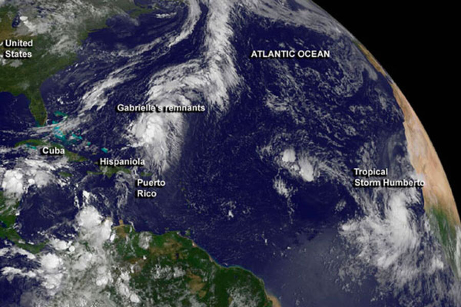
Tropical storm Humberto: Will it be the season's first hurricane?
Loading...
Tropical storm Humberto has formed off of the west coast of Africa, with the storm slated to become the Atlantic hurricane season's first hurricane by Tuesday evening, Eastern Daylight Time.
If the forecast holds up, Humberto would keep this year's hurricane season out of the record books for late bloomers. Since 1967, and perhaps longer, that distinction falls to 2002, when the season's first hurricane, Gustav, formed by 8 a.m. Eastern Daylight Time, Sept. 11, according to the National Hurricane Center in Miami.
That record may hold all the way back to 1944, when aircraft first began tracking tropical cyclones and measuring the conditions inside them, suggests Jeff Masters, director of meteorology at the website Weather Underground.
Although Humberto appears unlikely to unseat Gustav as the latest first hurricane to form in recent decades, it does edge 2001's Erin for the No. 2 spot.
The all-time record for a late arrival falls to a hurricane that formed Oct. 8, 1905, according to the National Hurricane Center.
Humberto, the 2013 season's eighth named storm, currently is dumping heavy rain on the southern Cape Verde Islands, where tropical storm warnings have been posted.
Humberto sports maximum sustained winds of 40 miles an hour, with tropical storm-force winds extending up to 60 miles from its center. Forecasters expect Humberto's maximum sustained winds to top out at about 90 miles an hour – making it a strong category 1 hurricane – by Thursday morning. By Saturday, its winds are expected to drop back to tropical storm strength.
Track forecasts call for the storm's center to hook northward after it clears the Cape Verde Islands overnight Monday, then take a jog to the northwest at the weekend. By then, Humberto's center is expected to be roughly 2,700 miles east of the Bahamas, well away from any land.
The 2013 Atlantic hurricane season, which runs from June 1 to Nov. 30, is well into its mid-August-through-late-October peak. And while the first hurricane is late to arrive, the season is running above normal for named storms as a whole. Based on the 1966-2009 average, the eighth named storm usually doesn't appear until around Sept. 24.
Several factors have held tropical storms' graduation to hurricane status at bay in the Atlantic, notes Dan Kottlowski, a senior meteorologist and hurricane expert at Accuweather, a forecasting firm in State College, Pa.
The wide sweep of clockwise winds from a mid-level high-pressure system centered off the coasts of Portugal and northern Africa has swung out over the Atlantic in the region where the storm systems that spawn tropical cyclones form. That has set up wind shear – a change in wind speed or direction with altitude – that can slow or prevent a storm system from organizing into a rotating tropical cyclone.
Forecasters have seen such features before, Mr. Kottlowski says, but "what's unusual is that it's been sitting there for almost two weeks."
At the same time, a large, persistent area of high pressure over the central US this summer has driven westerly winds deep into the low latitudes, where they turn to cross the Atlantic. This serves up its own wind shear and delivers relatively dry air into the main development region for Atlantic tropical cyclones.
Meanwhile, another surface persistent high-pressure system – this one between the Azores and Bermuda – has swept winds across Portugal and driven hot dry air deep into the main storm-forming region, as well, stifling storm formation. Humberto was preceded by three tropical-cyclone precursors – tropical waves – that encountered that dry air.
"There's three storms that bit the dust immediately," he says. "If that dry air wasn't there, these things probably would have been hurricanes."
Still, he cautions that the season isn't over yet. In 2001, when Erin made its late appearance, the season ended with nine hurricanes in the books. In 1998, hurricane Mitch formed in late October in the southern Caribbean. The storm killed 19 people and inflicted an estimated $6.2 billion in damage in Central America and on the Yucatan Peninsula.
This year, Kottlowsi says, conditions there appear much more fertile for tropical cyclone formation. The atmosphere has been delivering very little shear, a lot of heavy rain, and low surface pressures.
"There's a lot of factors in play that could still make this a fairly active season," he says.


