An artificial flood does good in the Grand Canyon
Loading...
| RIVER MILE 45, GRAND CANYON, ARIZ.
With quick flicks of his Japanese calligraphy brush, Dave Rubin sends dry sand particles flying into the wind. He’s crouched in a four-foot-deep sand trench with a trowel in one hand, brush in the other, and the Colorado River flowing behind him. Dr. Rubin, a US Geological Survey senior scientist, leans back and studies the sand layers, trying to read their story – the tale of this year’s three-day high-flow experiment that thundered down the Grand Canyon.
The trench is dug into a bankside sandbar, a highly desirable feature of the Grand Canyon for habitat, archaeological preservation, and recreational camping. Sandbars once peppered this stretch of the river, but the closing of the Glen Canyon Dam in 1963 began trapping millions of cubic yards of sand that had nourished them. In the last 12 years, three high-flow experiments have tried to re-create the floods that used to deliver the sand. The most recent one was in March.
Now scientists have descended on the canyon to study the outcome using a host of technologies, from simple shovels to underwater scans of the riverbed. Their findings, and their resulting suggestions on how to restore the canyon’s diminished sandbars, will then be thrown into the caldron of river and canyon management, where 25 stakeholders weigh such things as the interests of electrical power and water against the need to preserve a natural wonder and endangered species. Close to $80 million has been spent in the last decade on sedimentology and hydrology research. Environmentalists say the need for restoration is losing out to the need for electricity and water.
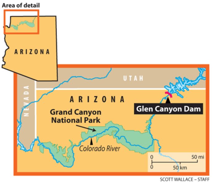
The Glen Canyon Dam, built on the upstream northeastern edge of the Grand Canyon, fundamentally changed the relationship between the canyon and the Colorado River.
“Artifacts of the existence of the dam are the clear water, the cold water, and steady low flows,” says Jack Schmidt, a watershed sciences professor from Utah State University. The tamed river, devoid of sand (close to 98 percent is stopped by the dam), now erodes through the sandbars and carries the sediment into Lake Mead, where it’s trapped behind Hoover Dam. According to researchers, the new behavior of the river has led to narrower rapids, eroded beaches, invasion of nonnative vegetation, and the loss of native fish. The Colorado River now has nearly twice as many nonnative fish species (60) as native ones (32), with the humpback chub population declining from 10,000 in 1989 to 6,000 in 2006.
In 1988, three groups – the Grand Canyon Trust, the Wildlife Federation, and the Western River Guides Association – sued to force the first environmental impact study of the Glen Canyon Dam, 25 years after it was finished. This led to the passage of the Grand Canyon Protection Act of 1992. The study that resulted found that the dam was negatively affecting fish habitat and sediment resources in the canyon.
Any sediment that enters the river below the dam settles to the riverbed and slowly bounces along the bottom. Pre-dam, periodic large floods would lift the sediment above the low-flow waterline and form sandbars, says Professor Schmidt. Part of the new management plan was to restore sandbars and beaches through so-called high-flow experiments.
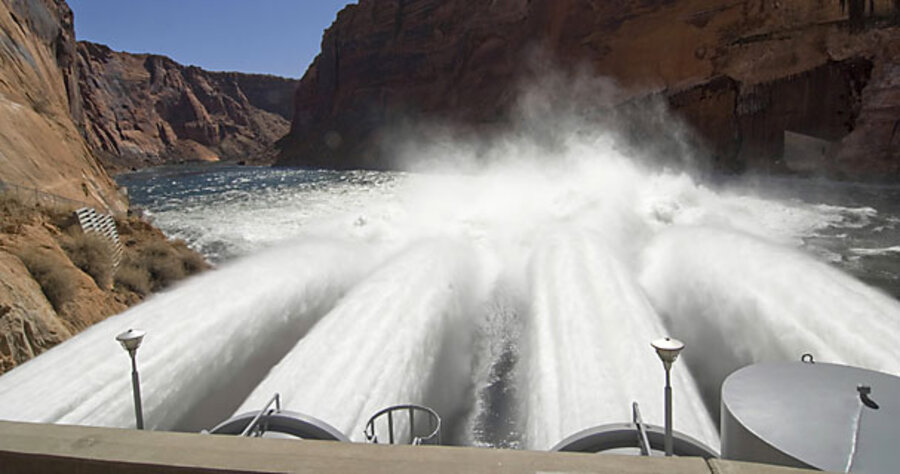
The March 2008 high-flow experiment was designed to move more than 1 million metric tons of Paria River sediment that could have otherwise dribbled downstream to the lake. For 60 hours, the jet-tubes at the base of the dam gushed around 41,500 cubic feet per second (cfs), 25,000 cfs higher than normally allowed.
Brad Warren, the Colorado River Storage Project manager at the Western Area Power Administration, which markets the power generated at Glen Canyon Dam, said the experiment has cost WAPA $4 million this year because it has had to purchase power to meet a contract – power that it could have generated from the water that bypassed the turbines.
The high flows do not alter water delivery: Irrigation projects and aqueducts that tap the river must stay at set levels, regardless of what happens at the dam.
Scientists prepared for the flood by burying chains vertically in sandbars. The meter-long “scour chains” were driven into the ground with the top link exposed. As the torrent passed, the sand around the chains washed away, toppling the chain link by link until the water receded. The dropped portion of the chain was then buried by newly arriving sand.
Rubin, Schmidt, and their teams relocated the chains and dug into the sandbars. Vertical faces of up to six feet were scraped clean, and the layers revealed if eddies had churned the riverbed and how long water stayed at an elevation. “We’re trying to understand the details of how these bars form,” Schmidt says.
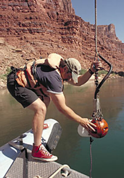
Even changes in grain size can help. A digital camera called the “flying eyeball” was developed to bounce along the riverbed and take photographs of individual sand grains. “It’s a 100-pound wrecking ball that we honed a cylindrical shape right through the middle of for the video camera,” says Hank Chezar, a USGS photographic technologist who designed and patented the instrument with Rubin. Photographs taken before and after the experiment help determine where new underwater sand deposits formed.
Although the scientists are not yet ready to release their findings, others are confident that the high flows, also done in 1996 and 2004, are helping. “These experiments are having a positive effect on the beaches,” says Stephen Martin, superintendent of Grand Canyon National Park. “The deposits exceeded our hopes.” This is good news for creating habitat for the endangered humpback chub and shoring up protective sand deposits on archaeological sites from native American tribes.
An advisory group to the US Department of the Interior, which owns and operates the dam, was set up in 1996 to balance the competing interests of preserving the Grand Canyon with modern demands for water and power. The Adaptive Management Working Group convenes 25 representatives from five federal agencies, the seven Colorado River basin states, native American tribes, environmental and recreational groups, and power-purchase coordinators. Here the scientists’ findings are fed into planning the flows to meet contract obligations for water delivery encoded by the “Law of the River,” an elaborate collection of state, federal, and international agreements governing the water rights.
Are scientific findings being weighed adequately? “The science has become extremely clear about what needs to happen at Glen Canyon Dam,” says Nikolai Lash, water program director at the Grand Canyon Trust, namely, “high flows done on an annual basis or near-annual basis followed by months of steady flows.” But Mr. Lash says that when votes are taken to set the flow levels, hydropower interests win every time. His organization is suing the federal government to follow the sediment-management guidelines spelled out in the Grand Canyon Protection Act.
“The dam is actually being operated illegally,” according to Lash.
Why windblown sand is important, too
Not all sand transport in the Grand Canyon is by water. Windblown sand movement, called aeolian transport, plays an big role in preserving thousand-year-old native American cultural sites. Windblown sand puts a protective sand layer on upslope terraces where tribal activities once occurred. The US Geological Survey (USGS) is studying how the operation of the Glen Canyon Dam affects the erosion of sand from the higher-elevation terraces.
“If dam operations contribute to erosion on archaeological sites, then the Bureau of Reclamation would have more responsibility for mitigating impacts above the pre-dam high-water line,” says Amy Draut, a USGS geologist leading the research.
Dr. Draut and her team erected 11 solar-powered weather stations and sand traps along the canyon. The traps, one-meter-tall towers with four wedge-shaped boxes that orient themselves into the wind, collect sediment that Draut uses to see how windblown sand changes with the size of a nearby sandbar and wind direction. “If you have a high-flow [event] build up a sandbar, you can cause more [aeolian] transport if the local wind direction is right,” she says. After the 2004 high-flow experiment, her team saw target sandbars and wind direction combine to double aeolian transport. Their findings after this year’s high flow may confirm that dam operations are risking the cultural heritage of the Grand Canyon.


